Chang Guang Satellite Technology Co., Ltd.(CGSTL), founded in December 1st, 2014, it is the first commercial remote sensing satellite company in China. With the total registered capital of 1.97 billion yuan, the company is composed of CIOMP, Jilin provincial government, and social capital.

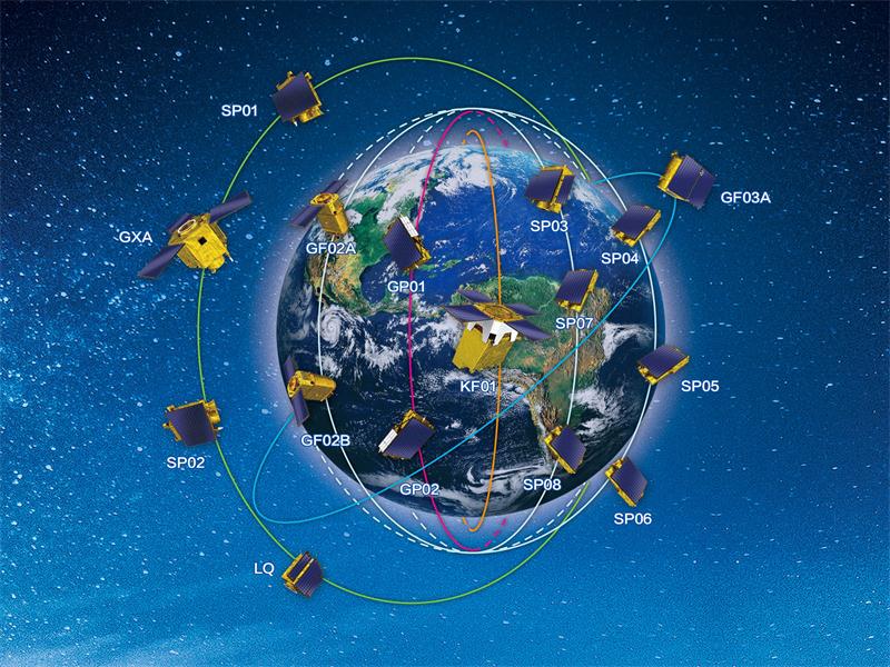
Jilin-1 satellite constellation is the core project under construction by CGSTL. The phase I of the project consists of 138 high-performance optical remote sensing satellites covering video, high resolution, wide band, infrared, multispectral and other series. At present, CGSTL has sent 79 Jilin-1 satellite constellation networking remote sensing satellites into the designated orbit through 20 launches (Currently the number of remote sensing satellites in orbit is 72). Up to now, CGSTL has built the world's largest sub meter commercial remote sensing satellite constellation, occupying a dominant position in remote sensing information services, it has gradually become an important global source of space remote sensing information. According to the calculation of the existing satellites in orbit, the Jilin-1 satellite constellation can visit anywhere in the world 23 to 25 times a day, with the ability to photograph a global twice a year and a national six times a year. It provides high-quality remote sensing information and product services for land security, geographic mapping, land planning, agricultural and forestry production, ecological environmental protection, smart cities and other fields, which is of great significance to the construction of digital China.
Focusing on the field of commercial space, CGSTL is the first commercial remote sensing satellite company in the whole industry chain, which integrates satellite research, development, operation management and remote sensing information services. Relying on the Jilin-1 remote sensing satellite data,CGSTL can provide customers with high time resolution, high spatial resolution, high spectral resolution, fast wide area coverage of satellite remote sensing data and comprehensive application services of spatial information based on satellite remote sensing data. At the same time, with its core technology accumulation in satellite platforms and space optical payloads, CGSTL is able to provide customers with customized satellite manufacturing and related services, including satellite whole and part components, test and test services, on-board services, and naming services.
Strictly adhering to the spirit of "unity, innovation, hard-work, and pragmatic", adopting the development concept of "mass development, broad innovation ", with the mission of “serving 7 billion people on the globe with the remote sensing information product integrating sky, space and ground”, aiming for " building internet-based remote sensing information platform, and constantly introduce innovative products ", the company goes all out to promote the industrial transformation and upgrading of Jilin Province, to drive the revitalization of the old industrial base in northeast China, and to strive to compose the brilliant chapter of the Chinese commercial remote sensing satellite!